
Knowing who is where.
As long as the incident commander can see their units, they do not need a map. This application matters where they cannot — a vegetation fire across several slopes, a search in woodland at night, a disaster relief operation, or pumping out a dozen addresses after a storm at the same time. FireAppX Tracking puts every unit into one shared situation picture: the incident commander sees where they are, and each unit sees the others.
- Runs in a web browser
- Android app
- Windows application
- LoRaWAN trackers can be connected
What for
When the incident commander can no longer see their units
At a room fire the incident commander stands in front of the house and sees everyone going in and coming out. Nobody needs a map for that. FireAppX Tracking is built for the other kind of incident — the ones where the overview breaks down:
-
Vegetation fire fighting
Several crews spread across slopes and patches of woodland, no line of sight, and the fire front is moving. Who is standing where, and where is the gap?
-
Searches
An area has only been searched if you know who was where. In the dark, in woodland, that cannot be held in your head without a map.
-
Disaster relief operations
In Austria these are called KHD operations: many units, often from several brigades, spread over a large area. Radio alone no longer carries the picture.
-
Storms and environmental incidents
Pumping out a dozen addresses at once, several units out at the same time. A situation picture answers in one glance what otherwise costs ten radio messages.
And when something happens
Every unit has a distress call. It goes to the incident commander and to incident command — and additionally to the units nearby, because they are there before anyone else can move up. The map then shows the bearing and the distance. In woodland at night, that is exactly the difference.
The connection
Incident command has internet: over LTE in the command vehicle, over Starlink, or at the district command staff in the fire station. Out in the field that is not always the case — so every device reports again as soon as it has coverage, and where there is none at all, there are the LoRaWAN trackers.

In service
FireAppX Tracking
- Application
- FireAppX Tracking, the first application under the FireAppX brand.
- Purpose
- A shared situation picture: vehicles, crews and incident command on one map.
- Devices
- Phone, tablet and the computer at incident command. In a web browser, and for Android additionally as an app.
- Without mobile coverage
- Where no network reaches, LoRaWAN trackers can be connected.
- In service with
- the volunteer fire brigade of Siegendorf, Burgenland, Austria.
- Language
- The user interface is German.
What FireAppX is
FireAppX is an umbrella brand for fire brigade software. It is being built in Austria by a serving firefighter — that is, by someone who takes the devices out on the incident himself and notices when something does not hold up when it matters.
There is currently exactly one application under this brand: FireAppX Tracking. Others will follow when there is a reason for them out of actual incident work.
01 Situation
What it looks like
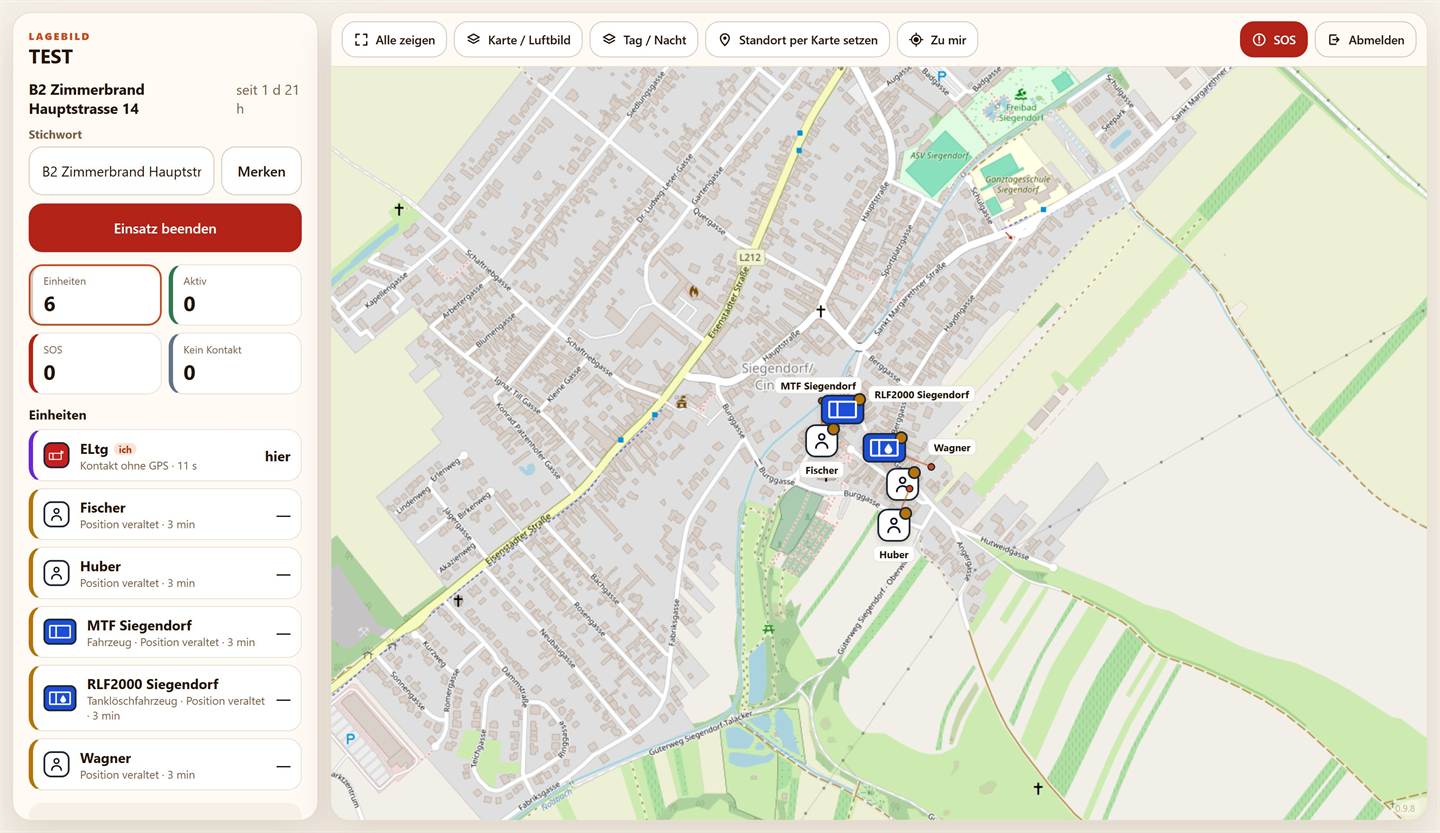
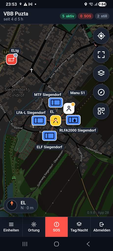
The colours are not a design choice; they are taken from the ground: incident command red like the command marking, vehicles blue like the beacon, crews white, the incident commander yellow like the high-visibility waistcoat.
-
Who carries a position
Every unit on the map is a signed-in device: the crew leader's phone, a tablet that stays in the vehicle, or a LoRaWAN tracker. Whoever carries nothing does not appear on the map — there is no tracking without a device. At Siegendorf it is Android tablets in the vehicles and phones with the crews.
-
How current a position is
A ten-minute-old position that looks current leads people astray. So every unit states its condition openly: after 90 seconds without a new satellite fix it reads Position veraltet (position stale), after 180 seconds without any report at all Kein Kontakt (no contact), and if a device does report but cannot get a satellite fix, Kontakt ohne GPS (contact without GPS). Alongside that, the battery level and the time of last contact.
If a device loses the network, or the phone goes into a pocket, the unit does not disappear: it stays at its last known place and visibly ages there.
-
Distress call from the device
One button. It reaches the incident commander, incident command and the units nearby, with bearing and distance to the caller.
-
After the incident
The course of the incident stays available: who was signed in when, what happened, and where. It can be exported as a spreadsheet — for the debrief, or as evidence if anyone asks afterwards.
02 Devices
What it runs on
-
In the browser
Nothing to install. The address, the brigade, and you are in. This is the way that works on every device — including the computer at incident command.
-
The Android app
For phones and tablets that stay in the vehicle. It keeps reporting while the screen is off, which a browser tab does not reliably do. It is currently distributed through an internal test channel — if you would like access, a short message via the imprint is enough.
-
On iPhone
In the browser. There is no separate iPhone app; adding the page to the home screen gives you the closest thing to one.
-
LoRaWAN trackers
Where mobile coverage ends, a tracker on the vehicle or with the crew keeps reporting over LoRaWAN. It sends less often and less precisely than a phone — but it sends where a phone no longer does.
03 Data
Where the crew's location data sits
Location data of colleagues is the most sensitive thing this application handles. So it is stated plainly rather than buried:
-
Only during an incident
Location reporting runs while a unit is signed in to an incident. Signed out means nothing is reported — there is no tracking outside an incident.
-
No user account
Nobody registers. There is no personal account, no e-mail address, no password for the crew. A unit joins an incident and leaves it again.
-
Who sees whom
Only within your own brigade, and only within the running incident. Another brigade sees nothing of yours.
-
How long it is kept
The course of an incident is kept so that it can be reviewed afterwards. The exact periods are in the privacy notice of the application.
-
Where the server stands
In Austria. No third-party analytics, no advertising networks, no external map service that would see your positions — the server fetches the map tiles itself and passes them on.
-
Responsibility
Each brigade decides for itself whether and how it uses the application. The details are in the German-language documents linked below.
The privacy notice of the application is at tracking.fireappx.com/privacy (German).
04 Getting started
What saying yes means
-
An area of your own
Your brigade gets its own area with its own identifier. Your data stays separate from every other brigade's.
-
Nothing to set up
No server, no installation, no maintenance contract. A browser is enough; the Android app is optional.
-
During the incident itself
Units join by QR code or a four-digit incident PIN. If anything is unclear, there is a short guide at tracking.fireappx.com/guide (German), and questions go through the imprint.
-
Changes are stated openly
Every release is listed at tracking.fireappx.com/changelog.
Take a look, or ask
The application is open — have a look at it. If you have questions, or if your brigade would like an area of its own, get in touch.